Home > Digitized Walters Manuscripts
This document is a tranformation of a TEI P5 XML manuscript description incorporating images. If you have trouble reading special or non-Latin characters on this page, please make sure you have appropriate Unicode fonts installed and an up-to-date web browser.
Walters Ms. W.73, Cosmography
Browse images (Browse images in a new window) | TEI in XML format
W.73
Cosmography
Authority name: Bede, the Venerable, Saint, 673-735
Authority name: Isidore, of Seville, Saint, d. 636
Authority name: Abbo, of Fleury, Saint, ca. 945-1004
Created in England in the late twelfth century, this manuscript was intended to be a scientific textbook for monks. The manuscript is brief at nine folios, and was designed as a compendium of cosmographical knowledge drawn from early Christian writers such as Bede and Isidore, as well as the later Abbo of Fleury. Those writers, in turn, drew on classical sources such as Pliny the Elder for their knowledge but adapted it to be understood through the filter of Christianity. The twenty complex diagrams that accompany the texts in this pamphlet help illustrate them, and include visualizations of the heavens and earth, seasons, winds, tides, and the zodiac, as well as demonstrations of how these things relate to man. Most of the diagrams are rotae, or wheel-shaped schemata, favored throughout the Middle Ages for the presentation of scientific and cosmological ideas because they organized complex information in a clear, orderly fashion, making this material easier to apprehend, learn, and remember. Moreover, the circle, considered the most perfect shape and a symbol of God, was seen as conveying the cyclical nature of time and the Creation as well as the logic, order, and harmony of the created universe. England is especially notable for the production of illustrated scientific textbooks, with the earliest examples produced during the Carolingian period under the influence of the noted Benedictine scholar Abbo of Fleury, who taught at Ramsey Abbey for two years. Although the grouping of texts and diagrams here is unique, the manuscript is related to other scientific compilations from this era, such as British Library, Royal Ms. 13 A.XI, Cotton Ms. Tiberius E.IV, and Oxford, St. John's College, Ms. 17.
Late 12th century CE
England
Book
Scientific
The primary language in this manuscript is Latin.
Parchment
Medium-weight parchment; shows heavy wear from use
Foliation: i+9+i
Modern pencil foliation upper right corners and middle of bottom margin; numbers match
Formula: Undetermined
Catchwords: None
Signatures: None
Comments: The binding is extremely tight; stitching is visible between fols. 6 and 7; the manuscript might currently be three single leaves followed by a ternion (fols. 4-9)
15.5 cm wide by 26.7 cm high
13.5 cm wide by 23.5 cm high
- Columns: 1-2
- Ruled lines: 64-69
- Plummet-ruled; ruling patterns and number of columns vary due to incorporation of diagrams in page layout
- Title: Compendium of computistical texts
- Authors: Bede, the Venerable, Saint, 673-735; Isidore, of Seville, Saint, d. 636; Abbo, of Fleury, Saint, ca. 945-1004
- Incipit: Ventus est aer commotus
- Contents: Text is a compilation of excerpts from early medieval scientific works, primarily by Bede, Isidore of Seville, and Abbo of Fleury: fol. 1v-2r: De ventis, Isidore, Etymologiae, XIII, xi; fol. 2r-v: De zodiaco circulo, Bede, De natura rerum, XVI; fol. 3r: De ortu solis, from Cui ideo, after Isidore, De natura rerum, XVII, 3; De solis equorum nominibus, pseudo Bede; De solstitio et equinoctio; De duodecim signis, Bede, De natura rerum, XVII; fol. 3v: De cursu et magnitudine solis, Bede, De natura rerum, XIX; De cursu planetarum, Bede, De natura rerum, XII; De stellis, Bede, De natura rerum, XI; De vario effectu siderum, Bede, De natura rerum, XI; De natura et situ lune, Bede, De natura rerum, XX; De eclipsi soli et lune, Bede, De natura rerum, XXII; De cometis, Bede, De natura rerum, XXIV; De aere, Bede, De natura rerum, XXV; De lacteo circulo, Bede, de natura rerum, XVIII; fol. 4r: Ubi non sit et quare, Bede, De natura rerum, XXIII; Denique luna totius zodiaci..., Abbonian text; fol. 4v: De cursu solis et lune; De cursu lunae per signa; De intervallis planetarum, Pliny, Naturalis historia II, xix-xx; Dimensio celestium spatiorum secundum quosdam, cf Isidore, De harmonia et coelesti musica, and Byrhtferth's gloss on Bede, De natura rerum; De absidibus planetarum, cf Pliny, Naturalis historia II, xii and xiii, and Bede, De natura rerum, XIV; fol. 5r: De positione et cursu septem planetarum, cf. Bede, De natura rerum, XII and Pliny, Naturalis historia, II, vi; fol. 5v: Sententia Abbonis de differentia circuli et spere; fol. 6r: Sententia Abbonis de cursu septem planetarum per zodiacum circulum; De ratione bissexti et embolismi; De quinque circulis, Isidore, De natura rerum, X, 1-2; fol. 6v: De quinque zonae caeli; De quinque circulis mundi et subterraneo siderum meatu, Bede, De temporum ratione XXXIV; fol. 7v: De partibus mundi, Isidore, De natura rerum, XI, 1-3; De quattuor temporibus, elementis, humoribus, from anon. iuxta Ysidorum; fol. 8v: De concordia maris et lunae; De aestu oceani, Bede, De natura rerum, XXXIX; fol. 9r: De trimoda ratione temporum et divisionibus corum, cf Isidore, Etymologiae, V, xxxv, 1, Bede, De ratione computi, I, Bede, De divisionibus temporum, I, Bede, De temporum ratione, II; He autem divisiones temporum (with table), cf Bede, de divisionibus temporum, I; fol. 9v: Quomodo ex minoribus temporum divisiones, cf. Bede, De divisionibus temporum I; Quibus modis soleat annus nominari
- Hand note: Scholastic book script, of Gothic origin
- Decoration note: Twenty scientific diagrams in total, some containing human and animal components but most designed as non-figural schemata; seventeen circular diagrams formed of concentric bands or divided into sectors, averaging 12.5-13 cm in diameter, on fols. 1r, 1v, 2r, 2v, 3r, 4r, 5r, 6v, 7r, 7v, 8r, 8v, and 9r; group of seven small roundels on fol. 5r measuring 1.5 cm across each; two square-shaped diagrams, one on fol. 5v measuring 13.4x13.8 cm, other on fol. 7v measuring 11x8.3 cm; diagrams drawn in red and dark brown ink with same, as well as green, used to write inscriptions; portions of diagrams filled with red, green, blue or yellow pigment; green and red initials throughout ranging from one to seven lines in height; rubrics in red; text in dark brown ink
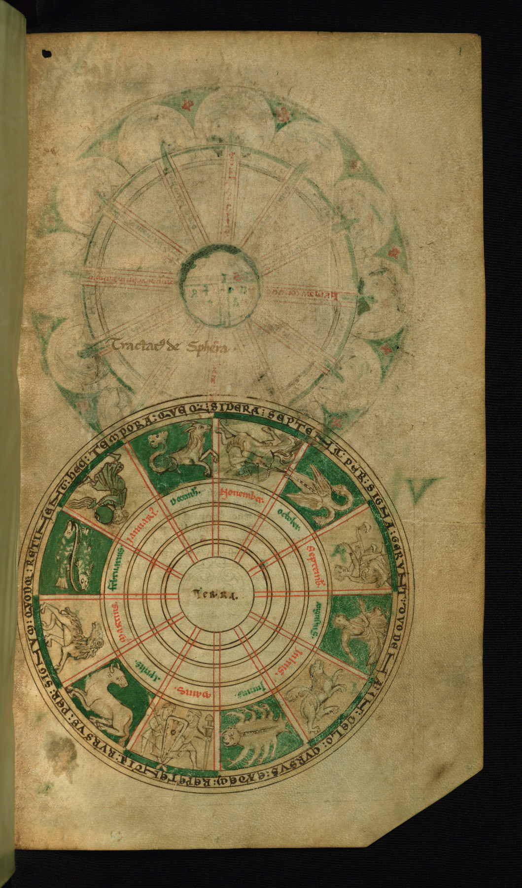
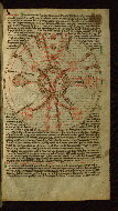
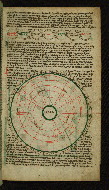
fol. 1r:
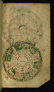
- Title: Diagram of the zodiac
- Form: Half-page illustration
- Text: None
- Label: The zodiac is the belt of twelve constellations through which the seven planetary bodies--the Sun, the Moon, and the five known planets--appear to pass during the course of a year. This wheel-shaped diagram shows the Earth at center, surrounded by the names of the months, the corresponding twelve signs of the zodiac, and an inscription explaining the relationships among the seven planetary bodies, the constellations of the zodiac, and the passage of time and its cyclical nature. Because it is the only illustration depicted on a blank page and the sole illustration that includes detailed, extensively colored figural imagery, the zodiacal diagram serves both as a frontispiece to the manuscript as a whole, and as an overview of the scientific and theological ideas presented in it.
- Comment:
A title, added in the thirteenth century, reads “Tractatus de sphera;” at the center of the diagram: “Terra”; in the fourth ring, the twelve months of the year; in the rim of the wheel, an inscription, beginning at ten o'clock: "hec tempora queque sidera septena per signa gerunt duodena in celo cursus eadem repetentia rursus per signum quodque retinent," or "The times carry the seven planets through the twelve constellations in the heavens. Their courses retain them [the planets], returning again through each constellation."
The signs of the zodiac were developed in the ancient Near East as navigational aids and entered the medieval repertoire through the intermediary of classical art. Although Greco-Roman traditions of representation carried considerable authority, medieval depictions of the zodiacal signs often departed from their classical models. Here, the twins of Gemini are portrayed not as nude youths but as armed, mail-clad soldiers carrying a single shield. Rather than eight legs and two claws or pincers, the scorpion of Scorpio has the wings of a bird or dragon and a pair of long, curving necks, each terminating in a snake-like head. For a scorpion with a dragon’s head and wings and a tail ending in three heads, see the Calendar of an early twelfth-century English manuscript containing Isidore of Seville’s Homilies, Cambridge, St. John’s College, MS B. 20, fol. 2v.
The zodiacal signs in their trapezoidal compartments are rendered in brown outline and flat blocks of pigment, their simplicity of execution being typical of illustrated scientific compilations produced in the monastic context. The schematic looping, V-shaped folds of the garments of Virgo and especially Aquarius compare with manuscript illumination and metalwork produced in England and on the Continent in the last decades of the twelfth century.
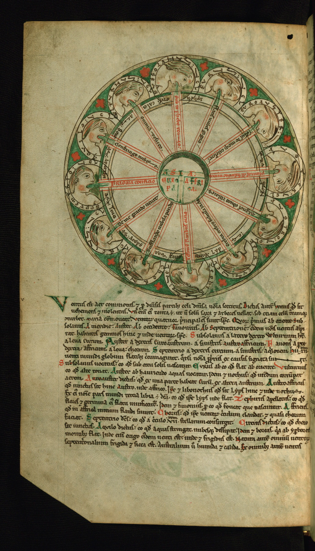
fol. 1v:
- Title: Diagram (rota) of the winds
- Form: Half-page illustration
- Text: Isidore: De ventis
- Label: The T-O map of the inhabited world occupies the center of this wheel-shaped diagram. Twelve profile busts of the winds, their Latin names provided in encircling bands, are depicted in the diagram’s wide outer ring; the narrower, unpainted ring just within it contains the winds’ Greek names. The four major winds are associated with the four cardinal directions, with East located at the top of the wheel. The busts of the winds blow toward the Earth at the center of the diagram, and their breath, represented as green strokes, flows into the wheel’s “spokes.” Each spoke bears a brief characterization of the associated wind, and these are expressed mainly in the first-person, as if spoken by the wind itself. Thus, the spokes of this diagram function like speech bubbles in a modern cartoon.
- Comment:
In the earth at center: “Asia,” “Europa,” “Affrica.” In the bands encircling the busts, the winds’ Latin names, with the Greek names given in the narrower, uncolored ring within. Beginning at the left (the North) and moving clockwise: “Septentrio vel Aparctias;” “Aquilo vel Boreas;” “Vulturnus vel Calcias”; “Subsolanus vel Apeliotes;” “Eurus vel;” “Euroauster;” “Auster vel Nothus;” “Austro vel” (for “Austroafricus”); “Affricus vel Lyps;” Zephirus vel Favonius;” “Chorus vel Argystes;” “Circius vel Tracias” (for “Thracias”), or “Septentrio or Aparctias;” “Aquilo or Boreas;” “Vulturnus or Calcias;” “Subsolanus or Apheliotes;” “Eurus or;” “Euroaster;” “Auster or Nothus;” “Austro or;” “Affricus or Lyps;” “Zephirus or Favonius;” “Chorus or Argystes;” “Circius or Tracias.” In the spokes, beginning at left (the North) and moving clockwise: “Frigora conficio,” or "I bring cold." “Constringo nubes,” I bind together/wring out the clouds." “Omnia desicco,” I dry up everything completely." “Subte phebe tono,” or "I thunder from beneath the [rising] Sun." “Flatus nubes gigno,” or "I cause the clouds to blow." “Tellus denique calescit,” or "The Earth finally becomes warm." “Pluuias cum fulmine initio,” or "I begin rain and lightning." “Magnos educo calores,” or "I draw out great warmth." “Crebra crebro fulmina iacto,” or "I hurl thunderbolts one after another." “Tellurem floribus orno,” or "I adorn the Earth with flowers." “Susstando (?) nubila pando,” or "Supporting, I spread out the clouds." “De me grando uenit,” or "From me comes hail."
The T-O map is a conceptual diagram intended to show the relative positions of the three continents. The T, the Mediterranean Sea, separates Asia, Europe, and Africa, while the O is the surrounding ocean. Although the origins of the T-O map lie in the literature of classical antiquity, some of the earliest surviving pictorial examples occur in early medieval manuscripts of the works of Isidore of Seville. The Middle Ages inherited from the Greco-Roman world both the twelve-wind scheme and the convention of its representation in diagram form. In medieval wind diagrams, the winds may be represented as frontal or profile animal or human masks, sometimes winged; as busts; or as nude or clothed personifications. For a precedent for the wind rota in W.73, see the Winchcombe Computus, an early twelfth-century manuscript made for St. Kenelm's Abbey, Winchcombe; London, British Library, Cotton MS Tiberius E. IV, fol. 30r.
The artist rendered the wind busts in simple brown outline, employing touches of red or brown on their brows, cheeks, jaws, and chests to suggest the contours of their faces and torsos.
While Aristotle and other ancient authorities characterized wind as a dry exhalation, Isidore defined it as air that is stirred up and moved. The depiction of the breath of the winds here appears to evoke both of these traditions. The red quatrefoils adorning the green spandrels between the framed busts and the diagram’s overall design are reminiscent of the tracery designs in contemporary rose windows, such as the early thirteenth-century rose on the western façade of the Cathedral of Notre-Dame, Chartres.
fol. 2r:
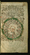
- Title: Diagram of the winds
- Form: Half-page illustration
- Text: Isidore: De ventis
- Label: Unlike the wind diagram on the preceding folio, this one is devoid of figural imagery or ornament. A schematic T-O map of the inhabited world occupies the center of the diagram. The wind names are written in the colored segments of the penultimate ring. Characterizations of each wind, comprising excerpts or adaptations of portions of the Spanish scholar Isidore of Seville’s (d. 636 CE) scientific work, De natura rerum (On the nature of things, XXXVII, i-iv), fill the corresponding trapezoidal sectors.
- Comment:
In the earth at center: “Asia,” “Europa,” “Affrica.” In the outer ring, beginning at the left (North), the names of the winds in colored capitals: “Septentrio” (North), “Aquilo,” “Vulturnus,” “Subsolanus” (East), “Eurus,” “Euroauster,” “Auster” (South), Euronothus,” “Affricus,” Zephirus” (West), “Chorus,” “Circius.” In the twelve corresponding sectors, beginning at left (North), the characterizations of each wind: “Ventorum primus cardinalis Septentrio qui et aparcias fri[gi]dus et niualis flat rectus ab axe. et facit arida. et frigora. et siccat nubes,” or “Septentrio (North Wind), the first of the cardinal winds, which is also called Aparcias, is cold and snowy. It blows straight from the North Pole and makes [everything] dry and cold and dries out the clouds.” “Aquilo ventus qui et boreas ex alto flat gelidus atque siccus et sine pluuia. quia non discutit nubes sed constringit,” or “Aquilo, the wind that is also called Boreas, blows from high up [i.e., the North]. It is icy and dry and without rain, because it does not disperse the clouds but binds them together/wrings them out.” “Vulturnus qui et boetias uocatus. dexter est Subsolani hic dissoluit omnia atque desiccat,” or “Vulturnus, which is also called Boetias, and is to the right of Subsolanus, scatters and dries up everything.” “Secundus cardinalis subsolanus qui et afeliotes. hic ab ortu intonat et est temperatus. Dicitur autem subsolanus ab ortu solis,” or “The second cardinal wind is Subsolanus (East Wind), which is also called Apeliotes. It thunders from the rising [of the Sun] and is temperate. Moreover, it is called Subsolanus [because it arises] beneath the rising of the Sun.” “Eurus ex sinistro latere ueniens subsolani. orientem nubibus irrigat Eurus dictus eo quod ab euro flat. id est ab oriente,” or “Eurus comes from the left side of Subsolanus and waters the East with clouds. It is called Eurus because it blows out of Euro, that is, the East.” “Auroauster [Euroauster] a dextris intonat Austri. Euroauster dictus quod ex una parte habeat eurum ex altero austrum,” or “Auroauster [Euroauster] thunders from the right of Auster. It is called Euroauster because it has on one side Eurus and on the other Auster.” “Tertius cardinalis uentus Auster qui et nothus. meridiane plage. humidus atque fulmineus generans largos imbres. et pluuias latissimas,” or “The third cardinal wind is Auster (South Wind), which is also called Nothus. It is from the South, and is moist and full of lighting, generating abundant clouds and widespread rain.” “Euronothus uentus temperatus et calidus. a sinistra parte austri spirat,” or “Euronothus is a temperate and warm wind. It blows from the left side of Auster.” “Affricus qui et lyps ex zephiri dextro intonans. generans tempestates et pluuias. nubium collisiones. tonitrua fulgura. fulminorum impulsus,” or “Affricus, which is also called Lyps, thunders from the right of Zephirus, generating tempests and rain. The pressure of the blows of clouds are thunderbolts and flashes of lightning.” “Quartus cardinalis zephirus qui et fauonius ab occidente interiore flat. hic hiemem frigore relaxat flores producit,” or “The fourth cardinal wind is Zephirus (West Wind), which is also called Favonius. It blows from the midst of the West. It eases the harshness of winter and produces flowers.” “Chorus qui et argestes ex sinistra parte fauovnii aspirat. et flante in oriente. nubile sunt in india serena,” or “Chorus, which is also called Argestes, blows from the left side of Favonius. It blows bearing clouds in the East, and tranquil weather in India.” “Circius qui et tracias a dextris septentrionis intonans facit nubes grandinumque coagulationes. circius dictus est eo quod euro sit iun[g]etus,” or “Circius, which is also called Tracias, thunders from the right of Septentrio. It makes clouds and coagulated (frozen?) hail. It is called Circius because it is joined with Euro (should be “Chorus”).”
The T-O map is a conceptual diagram intended to show the relative positions of the three continents. The T, the Mediterranean Sea, separates Asia, Europe, and Africa, while the O is the surrounding ocean. Although the origins of the T-O map lie in the literature of classical antiquity, some of the earliest surviving pictorial examples occur in early medieval manuscripts of the works of Isidore of Seville. The Middle Ages inherited from the Greco-Roman world both the twelve-wind scheme and the convention of its representation in diagrammatic form. The earliest extant manuscripts containing circular tables of the Latin and Greek wind names equipped with both the Isidorian text and the T-O map at center date to the ninth century; see for example an early ninth-century manuscript of the second book of Cassiodorus’s Institutiones, Bern, Burgerbibliothek, MS 212/I, fol. 109r.
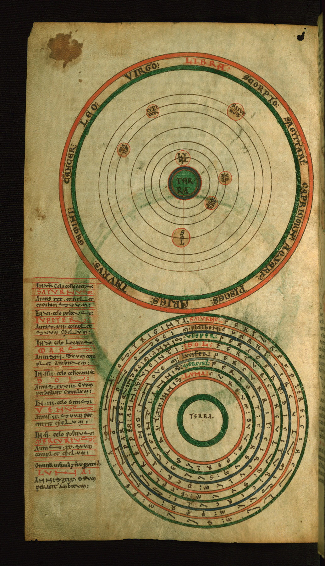
fol. 2v:
- Title: Top: Diagram of the planetary orbits and zodiac Bottom: Diagram of the planet cycles
- Form: Two half-page illustrations
- Text: Bede: De zodiaco circulo
- Label: The wheel diagram at the top of the page shows the Earth at center, with the seven heavenly bodies--the Moon, Mercury, Venus, the Sun, Mars, Jupiter, and Saturn--orbiting in concentric rings. The zodiacal names are given in the diagram’s frame. As had the ancients, medieval authorities believed that the Earth lay at the center of the universe, and that the Sun, Moon, and planets circled it. Also following ancient writers, medieval authors called the planets “wandering stars” because of their eccentric orbits: the word “planet” derives from the Greek “planetoi,” for “wanderers.” Their orbits were calculated according to the length of time it took them to complete one circuit of the zodiac. In the wheel diagram in the bottom half of the page, the Earth at center is surrounded by concentric bands containing the names of the heavenly bodies and the intervals of their orbits.
- Comment:
Top: In the earth at center: “Terra." In the planetary bodies, moving outward: “Luna,” “Mercurius,” “Venus,” “Sol,” “Mars,” “Iupiter,” “Saturnus.” In the outer band, the zodiacal signs, from the top: “Libra,” Scorpio,” “Sagittarius,” “Capricorn,” “Aquarius,” “Pisces,” “Aries,” “Taurus,” Gemini,” “Cancer,” “Leo,” “Virgo.” Bottom: In the earth at center: “Terra,” or “Earth.” From the outer ring, moving inward: “Saturnus fertur explere circulum suum per annos triginta,” or “Saturn is said to complete its circuit in thirty years.” “Phethon currit circulum suum per annos duodecim,” or “Phaethone [Jupiter] runs its circuit in twelve years.” “Vesper peragere dicitur circuli sui partes quindecim annis,” or “Vesper [should be “Mars”] is said to pass through its circuit in fifteen years.” “Sol fertur circulum suum explere per annos viginti,” or “The Sun is said to complete its circuit in twenty years.” “Lucifer percurrit circulum per annos novem,” or “Lucifer [Venus] runs through its circuit in nine years.” “Mercurius peragit cursum suum viginti annis,” or “Mercury passes through its course in twenty years.” “Luna cursum suum perlustrat xix annis,” or “The Moon traverses its course in nineteen years.”
A diagram of planetary cycles similar to the one at the bottom of W.73, fol. 2v occurs in the St. John’s Computus, an English manuscript made ca. 1110 at the monastery of Thorney in Cambridgeshire; see Oxford, St. John’s College, Ms. 17, fol. 37v. In the St. John’s College manuscript, the periods of the planetary orbits are not the usual ones given in Bede’s De natura rerum XIII and other sources, but the unusual intervals given in Isidore of Seville’s De natura rerum XXIII, 1-4. In W.73, the periods of the orbits for Saturn, Jupiter, and Mercury accord with Isidore’s numbers; the intervals for the other planetary bodies diverge from both the Isidorian and Bedan traditions.
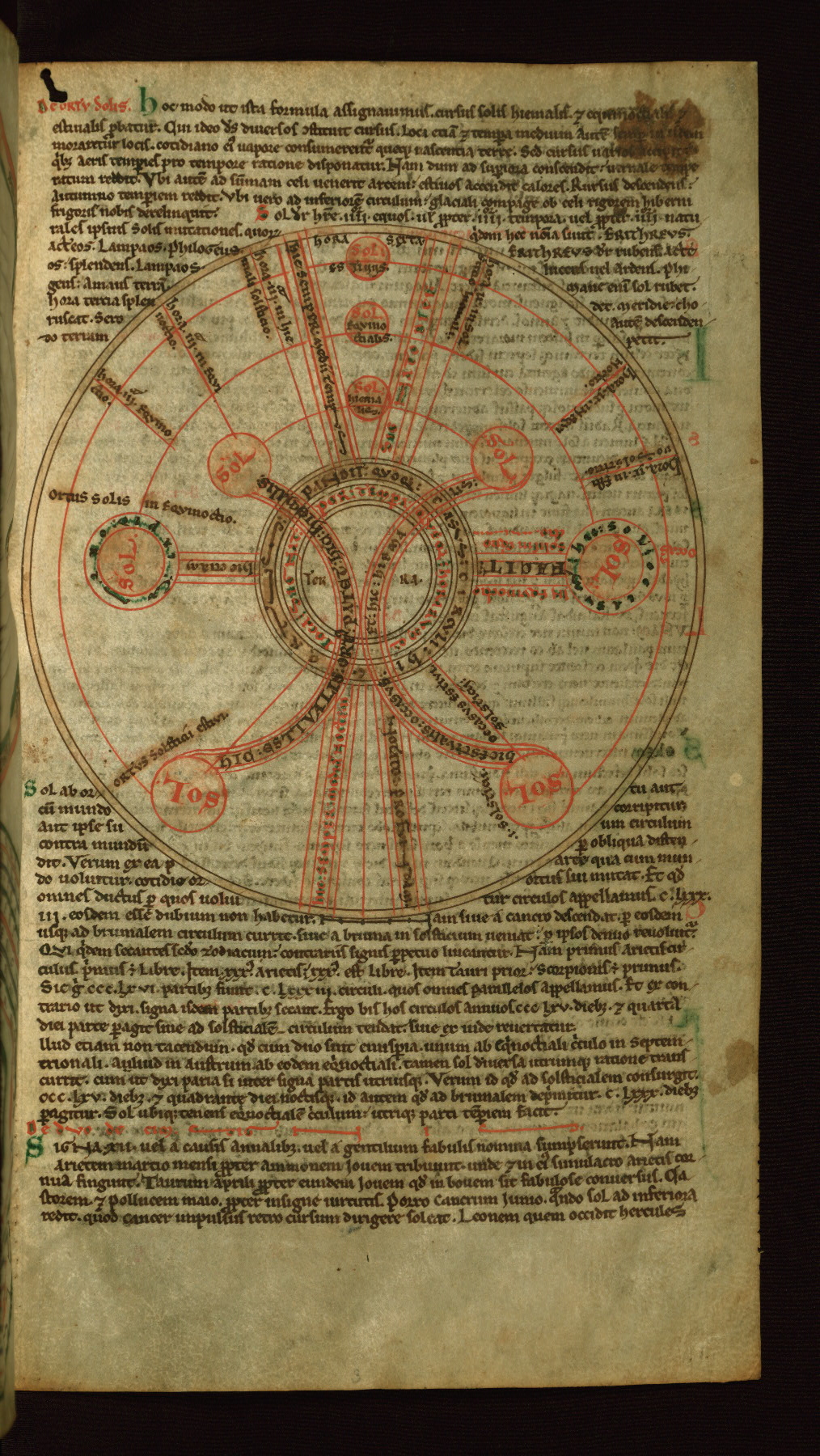
fol. 3r:
- Title: Diagram of the solstices and equinoxes
- Form: Half-page illustration
- Text: De solstitio et equinoctio
- Label: This diagram shows the positions of the Sun on the days of the solstices and equinoxes. The center constitutes the observer’s position, facing south (the diagram’s top). The thin yellow band framing the diagram is the horizon. Six yellow circles connected by three red arcs of decreasing size indicate sunrise (left) and sunset (right) at the summer solstice, the spring and autumn equinoxes, and the winter solstice respectively, while the arcs themselves show the Sun’s path above the horizon on these days. At the arcs’ midpoints are the midday Suns of the solstices and equinoxes. Six straight red lines on either side of the midday Suns indicate the Sun’s positions at the third and ninth hours on these days.
- Comment:
In the earth at center: “Terra;” in the circles that surround it: “Hic ortus pandit quoque casus circuli. Loca signat per tempora queque horarumque" or "Here the sunrise spreads through the calendar. It shows the places through the times and hours (?)". In the yellow discs representing the solstitial and equinoctial sunrises and the midday suns, in red: “Sol.” Alongside sunrise at the summer solstice: “Ortus solsticii estiui,” or "[Sun]rise at the summer solstice." Alongside sunset at the summer solstice: “I solsticii?” or "In the solstice?" and “Occasus estiui solsticii,” or "[Sun]set at the summer solstice." Alongside the equinoctial sunrise: “Ortus solis in equinoctio,” or “Sunrise at the equinox.” Around the equinoctial sunset: "hic solis occasus," or "here the setting of the sun." The band connecting the equinoctial sunrise and sunset: "facit hic etiam." Alongside the band: "in equinoctio solis in equinoctio (?)" Alongside the lines on either side of the midday Suns, from left: “Hora iii equinoctio,” or "The third hour at the equinox." “Hora iii in equinoctio,” or "The third hour at the equinox. “Hora iii in hiemilis solsticio,” or "The third hour at the winter solstice." “Hora ix in solsticio hiemalis,” or "The ninth hour at the winter solstice." “Hora ix in equinoctio,” or "The ninth hour at the equinox." “Hora ix in Estiuo equinoctio,” or "The ninth hour at the summer equinox." On the band to the left of the midday Suns: “Hic semper medii tempus,” or “Here it is always midday.” To the right: "Sic nato vici," or “Thus, with a change arisen.” On the straight bands beneath the central circles: “Nocto profundam,” or “Boundless night” and "hic semper media noctem," "here it is always the middle of the night." In the arced band connecting the solstitial and equinoctial suns (at left): “Hic estiualis ortus patet. Hic hiemalis,” or “Here opens (begins?) the summer [Sun]rise. Here [opens/begins] the winter [[Sun]rise].” At right: “Hic estiualis occasus. Et hic hiemalis,” or “Here is the summer [Sun]set. And here is the winter [[Sun]set].”
The oldest known version of this diagram occurs in the eighth-century C.E. Calendar of St. Willibrord, Paris, Bibliothèque nationale de France, Ms. lat. 10837, fol. 42r. In that manuscript, the diagram is called a horologium or sundial, and it also incorporates a compass figure and the face of a clock. Variant versions of this diagram are a common feature of the cosmographical sections of computus manuscripts. For a similar diagram of the sunrises and sunsets see the example in the St. John’s Computus, an English manuscript made ca. 1110 at the monastery of Thorney in Cambridgeshire; Oxford, St. John’s College, Ms. 17, fol. 35v.
fol. 4r:
- Title: Diagram of the phases of the moon
- Form: Half-page illustration
- Text: Bede: Ubi non sit et quare
- Label: This diagram illustrates the Moon’s phases in relation to its distance from the Sun. The Earth at center is surrounded by three concentric rings. Along the inner ring are seven discs showing the phases of the waxing and waning moon, indicated by pale yellow wash emanating from the Sun, at right. As the diagram makes clear, and as medieval authorities recognized, the Moon’s phases are determined by the extent of its illumination by the Sun. The cycle begins with the new, crescent Moon at upper right (approximately 2 o’clock) and moves counterclockwise, with the days of the lunar cycle given in red. It ends when the Moon is not visible -- that is, when it lies directly between the Earth and Sun, the latter labeled “Sol XXX.” This day was called by Isidore of Seville (d. 636 CE) the “interlunar interval” (Etymologiae III, lv).
- Comment:
In the earth at center: “Terra,” or “Earth.” In the large yellow discs representing the Sun: “Sol” and “Sol XXX,” or “Sun,” “Sun thirtieth [day].” In the discs representing the Moon, starting from upper right (approximately 2 o’clock) and moving counterclockwise: “Monoides,” “Diatomos,” “Amphicirtos,” “Luna XV,” “Amphicirtos,” “Diatomos,” “Monoides,” or “crescent Moon,” “half Moon,” “gibbous Moon,” “Moon fifteenth [day],” “gibbous Moon,” “half Moon,” “crescent Moon.” In the half-circle directly above the Earth: “Emisperium superius per quod luna a sole recedit que a nobis tota uidetur,” or “The hemisphere above the Earth is the one through which the Moon moves away from the Sun and is all that part [of the sky] that is seen by us.” And above that: “Emisperium dimidia pars spere est. Emisperion supra terram et ea pars celi,” or “The hemisphere is half of the sphere. The hemisphere is that part of the heavens above the Earth.” In the half-circle directly below the Earth: “Emisperium inferius per quod luna appropinquat soli. Emisperion sub terra est que uideri non potest quamdiu sub terra fuerit,” or “The hemisphere under the Earth is the one through which the Moon approaches the Sun. The hemisphere under the Earth is [the part] that cannot be seen as long as it is under the Earth.”
For a more schematic version of this diagram, see the example in the St. John’s Computus, an English manuscript made ca. 1110 at the monastery of Thorney in Cambridgeshire, Oxford, St. John’s College MS 17, fol. 38v.
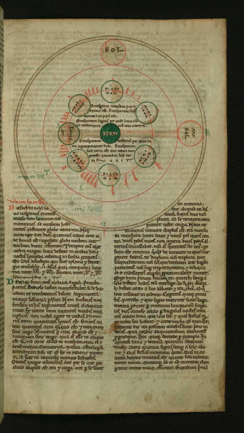
fol. 5r:
- Title: Above: The harmony of the spheres; Below: The planetary orbits
- Form: Above: Small illustration, 3 lines high; Below: Half-page illustration
- Text: Bede: De positione et cursu septem planetarum
- Label: The idea of the harmony of spheres – that numerical proportions corresponding to musical harmonies governed both the movement of the seven heavenly bodies and their distance from the Earth – was taken up by medieval writers from ancient thought. In the illustration of the harmony of the spheres in the upper part of the page, the Sun, the Moon, and the five known planets are depicted as seven discs of equal size. Between them are written musical intervals -- a tone (tonus), a semitone (semitonium), or three semitones (tria semitonia). The diagram below shows the Earth at center. The names of the zodiac are written in the outer frame. The names of the planetary bodies are written above their orbits, shown as red rings. Because each of these heavenly bodies has its own, eccentric orbit, the rings representing their orbits are not concentric.
- Comment:
In the illustration of the harmony of the spheres, from left to right: “Saturnus;” “Semitonium.” “Iuppiter;” “Semitonium.” “Mars;” “Tonus.” “Sol;” “Tria Semitonia.” “Venus;” “Semitonium.” “Mercurius;” “Semitonium.” “Luna.” In the diagram of the planetary orbits: In the earth at center: “Terra.” The planetary bodies, moving out from center: “Luna,” Mercurius,” “Venus,” “Sol,” “Mars,” Iupiter,” “Saturnus.” In the frame the names of the zodiac, from the top: “Capricornus,” “Aquarius,” “Pisces,” “Aries,” “Taurus,” “Gemini,” “Cancer,” “Leo,” “Virgo,” “Libra,” “Scorpio,” “Sagittarius.”
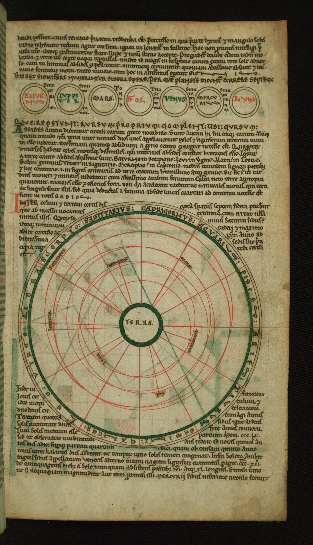
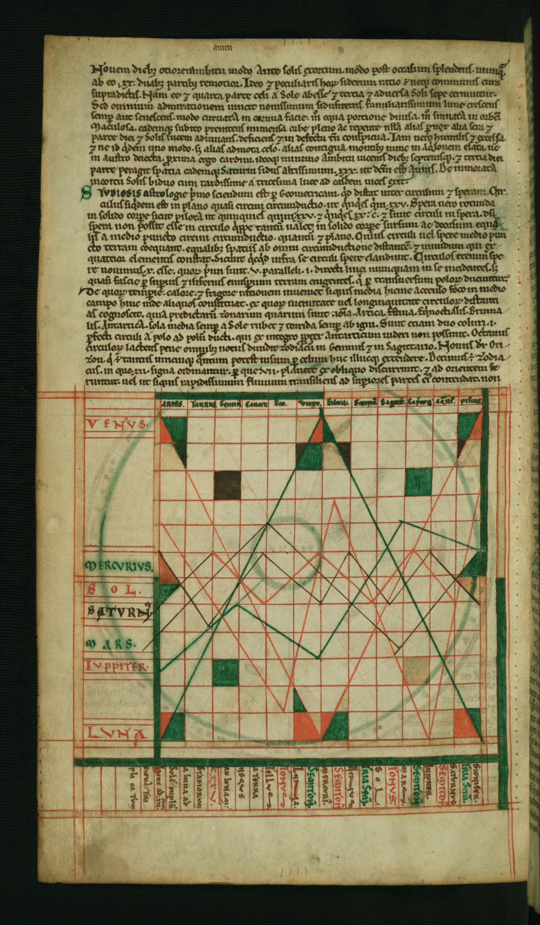
fol. 5v:
- Title: Diagram of planetary courses in the zodiacal signs
- Form: Half-page illustration
- Text: Abbo of Fleury: Sententia Abbonis de differentia circuli et sphere
- Label: In this diagram, the names of the seven planetary bodies – the Sun, the Moon, and the five known planets – are written along the vertical, at left. At top, along the horizontal, are the zodiacal names. One may follow the path of each planetary body through the zodiac by reading the graph from left to right. The diagram gives a sense not only of the independence of each planet’s orbit, but also of the different lengths of time it took each planet to complete one circuit of the zodiac. Along the bottom of the diagram is a list of the planetary bodies, with their distances given as musical values -- a tone (tonus), a semitone (semitonium), or three semitones (tria semitonia) -- as well as an abbreviated account of interplanetary distances, given as proportions of the distance from Earth to the Moon.
- Comment:
Along the vertical, from the bottom: “Luna,” "Iuppiter,” “Mars,” "Saturn,” “Sol,” “Mercurius,” “Venus.” Along the horizontal, at top, from left to right: “Aries,” “Taurus,” “Gemini,” “Cancer,” “Leo,” “Virgo,” “Libra,” “Scorpio,” “Sagittarius,” “Capricornus,” “Aquarius,” “Pisces.” Along the bottom, reading from left to right, beginning with “Tellus” (Earth): “Tellus. Tonus. Luna. Semiton(ium). Mercuri(us). Semiton(ium). Venus. Tria Semi(tonia). Sol. Tonus. Mars. Semiton(ium). Saturnus. Tria Semi(tonia). Signifer.” Along the bottom, reading from right to left, beginning with “A Terra”: “A Terra usque ad Lunam CXXV stadiorum. A Luna ad Sole(m) duplu(m). Hinc ad XII signa triplicatum,” or “From the Earth all the way to the Moon is 125,000 stadia, and double that from the Moon to the Sun, and three times that [from the Sun] to the zodiacal signs.”
A similar version of this diagram occurs in the Winchcombe Computus, an early twelfth-century manuscript made for St. Kenelm's Abbey, Winchcombe; see London, British Library Cotton MS Tiberius E. IV, fol. 142r. In the St. John’s Computus, an English manuscript made ca. 1110 at the monastery of Thorney in Cambridgeshire, the graph is rectangular rather than square; see Oxford, St. John’s College MS 17, fol. 38r.
The artist colored some of the individual squares and triangles within the diagram for decorative effect.
A “stade” equaled 600 Greek feet, a distance estimated to be the equivalent of anywhere from 517 to 607 feet.
fol. 6v:
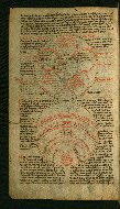
- Title: Above: Diagram of the celestial climate zones; Below: Diagram of the terrestrial climate zones
- Form: Two 1/3 page illustrations
- Text: Abbo of Fleury: De quinque zonis celi
- Label: Following ancient writers, medieval scholars identified five climactic zones: the Arctic and Antarctic, or North and South frigid zones; the North and South temperate zones, extending from the Tropic of Cancer to the Arctic Circle and the Tropic of Capricorn to the Antarctic Circle; and the torrid zone between the two tropics. Only the temperate zones were thought to be habitable. In the upper diagram, the five climate zones are shown in an abstract configuration resembling a flower with five circular petals. In his De natura rerum, Isidore of Seville (d. 636 CE) relates the zones to the five fingers of the human hand. As the hand was a fundamental mnemonic tool in the ancient and medieval worlds, Isidore’s likening of the petals to fingers makes this diagram an effective memory device. In the lower diagram, the zones are rendered as if projected onto the globe, as arcs and circles.
- Comment:
In the center of the upper diagram: “Emerinos latine dicitur dies atque nox,” or “Emerinos in Latin is called the day and the night.” In the “petals” of the diagram, beginning at lower left: “Primus cyclus Arcticos frigore inhabilitabilis,” or “The first zone, the Arctic, is cold and uninhabitable.” “Secundus thermos temperatus habitabilis,” or “The second [zone] is warm, temperate, and habitable.” “Mediuus ysemerinos torridus inhabitabilis,” or "The middle zone is torrid and uninhabitable.” “Quartus exemerinos temperatus habitabilis,” or "The fourth zone is temperate and habitable.” “Quintus cyclus Antarcticos frigidus inhabitabilis,” or "The fifth zone, the Antarctic, is cold and uninhabitable.” In the lower diagram, at center: “Ethiopum Terra," or “The land of Ethiopia.” Within or along the arcs and in the circle at the bottom of the diagram, reading from top down: “Circulus Australis qui est frigore inhabitabilis,” or “The southern cycle, which is cold and uninhabitable.” “Circulus inter frigus et calorem habitabilis,” or “The cycle between the cold and hot is habitable.” “Circulus solis ardore torrens et inhabitabilis,” or "The circle of the heat of the Sun (the equatorial circle) is torrid and uninhabitable.” “Circulus inter calorem et frigus habitabilis,” or “The circle between the hot and cold is habitable.” “Circulus inhabitabilis frigore,” or “The (Arctic) circle is uninhabitable on account of cold.”
Diagrams of the celestial climate zones appear frequently in scientific manuscripts from the ninth century; see for example a computus manuscript made after 861 at Fleury or Nevers in northeast France; London, British Library Harley MS 3017, fol. 90v. In a tenth-century manuscript of Isidore’s De natura rerum, the diagram’s resemblance to a flower is emphasized; see Paris, Bibliothèque nationale de France MS latin 6649, fol. 8v. The two climate diagrams on W.73, fol. 6v also appear together in the St. John’s Computus, an English manuscript made ca. 1110 at the monastery of Thorney in Cambridgeshire, and in the Peterborough Computus, produced at Peterborough ca. 1122-1135; see Oxford, St. John’s College MS 17, fol. 40r and London, British Library Cotton Tiberius MS C. I, fol. 11v.
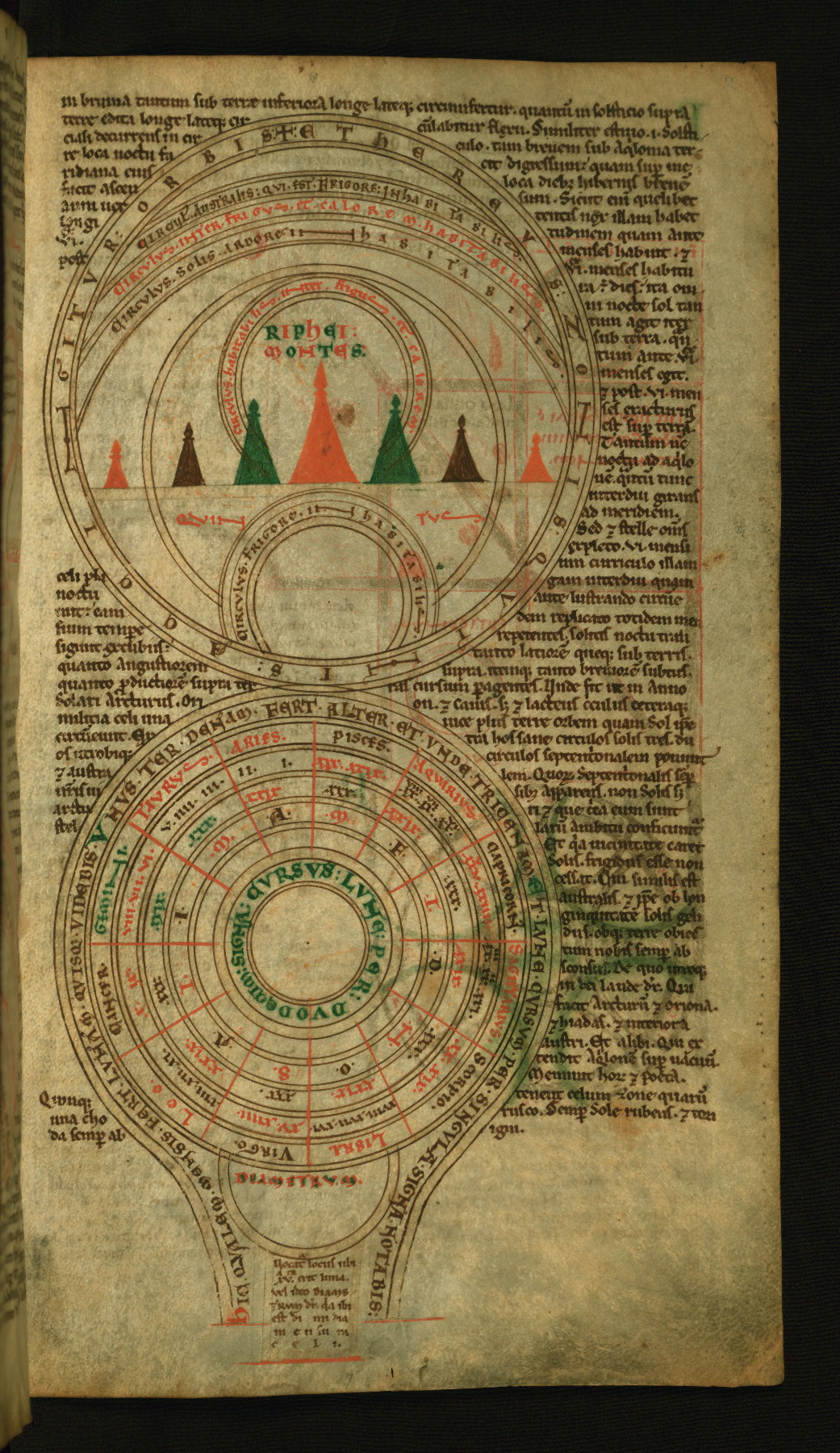
fol. 7r:
- Title: Above: Diagram of the terrestrial climate zones with the Riphaean mountains; Below: Diagram of the circuit of the moon in the zodiac
- Form: Two half-page illustrations
- Text: Bede: De quinque circulis mundi et subterraneo siderum meatu
- Label: In the diagram in the top half of the page, the observer’s point-of-view is the North Pole. This diagram is similar to the one in the lower part of fol. 6v, except that it also shows the Riphaean Mountains – a mythical range of peaks thought to mark the boundary between Asia and Europe, and the Arctic and North temperate zones -- represented as seven abstract, colored silhouettes resembling triangular game-pieces. The diagram in the bottom half of the page charts the course of the Moon through the zodiac, correlating the lunar or synodic months and the zodiacal signs. According to the De natura rerum (On the nature of things) of the English scholar, Bede (d. 735 CE), the Moon journeys through the zodiac thirteen times in twelve lunar months; thus, it runs through each zodiacal sign in a little over two days and six hours.
- Comment:
In the upper diagram, at center: “Riphei Montes,” or “The Riphaean Mountains.” Within or along the arcs and in the circle at the bottom of the diagram, reading from top down: “Circulus Australis qui est frigore inhabitabilis,” or “The southern cycle, which is cold and uninhabitable.” “Circulus inter frigus et calorem habitabilis,” or “The cycle between the cold and hot is habitable.” “Circulus solis ardore inhabitabilis,” or "The circle of the heat of the Sun (i.e., the equatorial circle) is uninhabitable.” “Circulus habitabilis inter frigus et calorem habitabilis,” or “The circle between the cold and heat is habitable.” “Circulus frigore inhabitabilis,” or "The [Arctic] circle is cold and uninhabitable.” Around the rim of the diagram: “Ethereus zonis quint[i]s accingitur orbis,” or “The circle [of the world] girded by the five celestial zones.” Below the Riphaean Mountains, in red: “Quintus,” or “Five.” In the lower diagram, reading outward: Innermost ring: “Cursus lune per duodecim signa,” or “The course of the Moon through the twelve zodiacal signs.” In the third ring from center: The first letters of the names of the twelve months of the year, reading counterclockwise from the top and beginning with “A” for April. In the fourth ring: The number of lunar days in each month -- either XXIX or XXX. In the fifth ring: The days of a single siderial month, numbered I-XXX and reading counterclockwise from the top. The numbers in this ring are the days of the siderial month in which the Moon is in the zodiac sign named in the corresponding sector of the sixth ring (the next ring out). In the sixth ring: The twelve names of the zodiac, reading counterclockwise from the top, beginning with Aries. In the outer ring, beginning at bottom left: “Hic qualem mensis fert lunam quisque uidebis. Unus ter denam fert alter et unde tricenam. Et lune cursus per singula signa notabis,” or “Here you will see what sort of moon each month brings. The one moves three times ten, the other, and whence thirty (?). And you will note the course of the Moon through each zodiacal sign.” At the bottom, a small inscription describes the middle of the moon's monthly course: "Diametrum vocatur locus ubi xv erit luna vel ideo Diane terminum (?) dicitur quia ibi est dimidium men[s]ium celi."
In the version of the diagram of the terrestrial climate zones in the St. John’s Computus, an English manuscript made ca. 1110 at the monastery of Thorney in Cambridgeshire, the Riphaean Mountains are represented as a zig-zag; see Oxford, St. John’s College MS 17, fol. 87v. The St. John’s Computus contains a similar diagram of the Moon’s circuit through the zodiac, as does the Winchcombe Computus, an early twelfth-century manuscript made for St. Kenelm's Abbey, Winchcombe; see Oxford, St. John’s College MS 17, fol. 77v and London, British Library Cotton MS Tiberius E. IV, fol. 62r.
A sidereal month is the time the Moon takes to complete one full orbit of the Earth in relation to the background stars. A sideral month lasts about 27 1/3 days, while a synodic or lunar month – the period of the Moon’s phases – is about 29 ½ days. A synodic month is longer than a sideral month on account of the fact that the Earth orbits the Sun: as a result, the Moon must travel slightly more than one full orbit of the Earth to get from one new moon to the next.
fol. 7v:
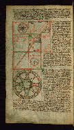
- Title: Above: Diagram of a cube; Below: Diagram of the microcosmic-macrocosmic harmony
- Form: Two 1/3 page illustrations
- Text: Isidore: De partibus mundi
- Label: Two overlapping squares with a common diagonal create the cube in the upper diagram. The Sun is portrayed in the upper left corner, the Moon in the lower right. The four elements, Earth, Air, Fire, and Water, along with their respective properties, occupy the cube’s upper square. The wheel-shaped diagram in the bottom part of the page visualizes the idea that Man is a microcosm of the universe, and the universe a macrocosm of Man. Within the ring at center are the words (reading from top to bottom) “World,” “Man,” and “Year.” The eight intersecting arcs illustrate the relationships among the parts of the world – the four elements, the four bodily humors, and the four seasons. The cross shape created by the arcs expresses Christ’s role in restoring to nature its original harmony, order, and meaning, believed to have been disrupted by the Fall of Man.
- Comment:
In the upper diagram, in the center square, moving clockwise from left: “Hec figura solida est secundum geometriciam rationem,” or "This solid figure is according to the rule of geometry." “Ennagonus Sol,” or "The seven-fold Sun." “Ignis. Tenuis. Acutus. Mobilis,” or "Fire. Light (Weightless). Sharp. Mobile." “Aer. Mobilis. Acutus. Crassus,” or "Air. Mobile. Sharp. Dense." “Aqua. Crassa. Obtunsa (for "Obtusa"). Mobilis,” or "Water. Dense. Dull. Mobile." “Terra. Crassus. Obtusas. Immobilis,” or "Earth. Dense. Dull. Immobile." “Eptagonus Luna,” or "The seven-fold Moon." In the lower diagram, at center: “Mundus. Homo. Annus,” or “World. Man. Year.” Beginning at the top of the diagram, the outer ring and “bars” of the cross, moving clockwise: “Ignis. Siccus. Calidus: Estas, colera rubea,” or "Fire. Dry. Warm: Summer, angry bile." “Aer. Calidus. Humidis: Ver, sanguis,” or "Air. Warm. Moist: Spring, blood." “Aqua. Humida. Frigida: Hiemps phlegma,” or "Water. Moist. Cold: Winter, phlegm." “Terra. Frigida. Sicca: Autumnus. Colera. Mela[ncholia],” or "Earth. Cold. Dry: Autumn, [black] bile, melancholy."
Versions of the cube diagram occur in London, British Library Harley MS 3017, fol. 90v, a computus manuscript made after 861 CE at Fleury or Nevers in northeast France; and the St. John’s Computus, an English manuscript made ca. 1110 at the monastery of Thorney in Cambridgeshire, see Oxford, St. John’s College MS 17, fol. 39r. The diagram of the microcosmic-macrocosmic harmony also appears in the St. John’s Computus; see Oxford, St. John’s College MS 17, fol. 39v.
The cube illustrates the mathematical equilibrium believed to exist among the different degrees of angularity, density, and mobility of the four created elements, Earth, Air, Fire, and Water.
fol. 8r:
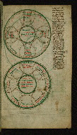
- Title: Above: Diagram of the harmony of the year and seasons; Below: Diagram of the harmony of the elements, seasons, and humors
- Form: Two half-page illustrations
- Text: Anon., iuxta Ysidorum: De quattour temporibus, elementis, humoribus
- Label: Both of these wheel-shaped diagrams resemble in their structure the diagram of the microcosmic-macrocosmic harmony on the preceding page. The eight intersecting arcs of the top diagram show the relationships among the four seasons, the four qualities of the year, the four cardinal directions, and the dates of seasonal changes. Thus, this diagram illustrates the notion of the unity of time and space as expressed in the Spanish scholar Isidore of Seville’s (d. 636 CE) scientific work, De natura rerum (On the nature of things, X). The bottom diagram illustrates the relationships among the four elements – Earth, Air, Fire, and Water – the four seasons, and the four bodily humors – phlegm, blood, yellow bile, and black bile -- as well as giving qualities associated with each. These relationships, first articulated by classical authorities and reprised in Isidore’s De natura rerum, XI, iii, form the basis of medieval medicine.
- Comment:
In the top diagram, at center: “Annus cuius communionis hec est figura.” or "The year, of whose communion this is the figure." Starting at the top and moving clockwise: “Ver oriens iiii Kalends Martii. ix.? Diebus. ii,” or "Spring East 4 Kalends March 9 days 2." “Calidus,” or "Warm." “Estas meridies viii Kalends Iunius. Diebus. xv,” or "Summer South 8 Kalends June 15 days." “Sicca,” or "Dry." “Autumnus occidens x Kalends Septembrio Diebus xviii,” or "Autumn West 10 Kalends September 19 days." “Frigidus,” or "Cold." “Hiemps septemtrio viii Kalends Octobrio Diebus xx,” or "Winter North 8 Kalends October 20 days." “Humida,” or "Moist." In the bottom diagram, at center: “Communio elementorum mundi temporum anni humorumque corporis humani,” or “The communion of the elements of the world, the seasons of the year, and the humors of the human body.” Starting at the top and moving clockwise: “Ignis calidus et siccus estas calida et sicca,” or "Fire is warm and dry, summer is warm and dry." “Aer calidus et humidus ver humidus et calidus,” or "Air is warm and moist, spring is moist and warm." “Aqua humida et frigida hyemps humida frigida,” or "Water is moist and cold, winter is moist and cold." “Terra frigida et sicca Autumnus frigidus et siccus,” or "Earth is cold and dry, Autumn is cold and dry." “Colera rubuea sicca et calida,” or "Red, angry bile (or yellow bile) is dry and warm." “Sanguis humidus et calidus,” or "Blood is moist and warm." “Flegma humidum et frigidum,” or "Phlegm is moist and cold." “Melancolia humida et frigida,” or "Black bile is moist and cold."
For simpler versions of the two diagrams on W.73, fol. 8r, see London, British Library Cotton MS Vitellius A. XII, fols 50v and 52v, a late-eleventh-century manuscript with twelfth-century additions made in Salisbury, England.
fol. 8v:
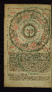
- Title: Tidal diagram (rota)
- Form: Half-page illustration
- Text: Bede: De aestu oceani
- Label: This wheel-shaped diagram illustrates the monthly movement of the tides, and shows the correspondences between the tides and the age of the Moon as set out in the English scholar Bede’s (d. 735 CE) De natura rerum (On the nature of things, XXXIX). The T-O map of the inhabited world occupies the diagram’s center. The twelve sectors contain brief characterizations of the twelve winds. The first of the three outer rings shows four tidal cycles of seven or eight days each; the next ring, labeled “water” (aqua) thirty times, represents the ocean surrounding the world. The last ring in this group gives the days of the lunar or synodic month, beginning at top. The four small circles at the corners--perhaps four representations of the Moon--give the days of the two lesser (or lowest) tides and the two greater (or highest) tides of the month.
- Comment:
In the band around the diagram’s circumference: “Mare lune altum luci flue sic obsequitur,” or "The deep sea complies with the light of the flowing moon." At the center: “Asia. Europa. Affrica.” In the band around the center: “Partibus his terris totus distin[g]uitur orbis,” or "The whole orb is divided into parts by these lands." In the twelve sectors, beginning at left (the North): “Ventorum primus cardinalis Septentrio frigidus et niualis facit frigora et niues,” or “The first of the cardinal winds, Septentrio, is cold and snowy and makes cold and snow.” “Aquilo sinister Septentrionis gelidus atque siccus non discutit nubes sed distringit,” or “Aquilo, to the left of Septentrio, is icy and dry. It does not disperse the clouds but draws them apart.” “Vulturnus qui et calcias dextrior Subsolani hic dissoluit cuncta et desiccat,” or “Vulturnus, which is also called Calcius, is to the right of Subsolanus. It breaks up and dries out everything.” “Secundus cardinalis Subsolanus ab ortu intonat Solis et est temperatus,” or "The second cardinal [wind], Subsolanus, thunders from [beneath] the rising of the Sun and is temperate.” “Eurus sinister Subsolani orientem nubibus semper irrigat,” or “Eurus, to the left of Subsolanus, always waters the East with clouds.” “Euroauster calidus ventus a dextris intonat Austri,” or “Euroauster is a warm wind. It thunders from the right of Auster.” “Tertius cardinalis Auster humidus calidus atque fulmineus,” or “The third cardinal wind, Auster, is moist, warm, and bears lightning.” “Euronothus ventus temperatus calidus a sinistris Austri aspirat,” or “Euronothus is a temperate and warm wind. It blows from the left of Auster.” “Affricus dexter zephiri generat tempestates et pluuias et facit fulminum impulsus,” or “Affricus to the right of Zephirus generates storms and rain, and makes lightning strikes.” “Quartus cardinalis zephirus hiemem resoluit floresque producit,” or “The fourth cardinal wind, Zephirus, breaks winter and produces flowers.” “Chorus qui et argestes ex sinistra parte fauonii aspirat,” or “Chorus, which is also called Argestes, blows from the left side of Favonius.” “Circius dexter Septrionis facit niues et gra[n]dinum coagulationes,” or “Circius to the right of Sept[ent]rio makes snow and coagulations of hail.” In the moon-discs at the corners, beginning at upper right and moving clockwise: “Luna v incipit ledona,” or "The fifth lunar day begins the lesser tide." “Luna xiiii incipit malina,” or "The fourteenth lunar day begins the greater tide." “Luna xx incipit ledona,” or "The twentieth lunar day begins the lesser tide." “Luna xxviii incipit malina,” or "The twenty-eighth lunar day begins the greater tide." Around the sides of the page, beginning at upper right: “Monstrant ledones hoc iugiter atque maline scilicet accessus maris assiduusque recessus ens egit lune tumidum mare cedit exoritur luna mox effluit et maris unda occidit et luna refluendo recurrit,” or "The greater and lesser tides show this continually [and] of course the constant ebb and flow of the sea... The moon arises and soon recedes and the swell of the sea diminishes, and the moon returns flowing back."
The T-O map is a conceptual diagram intended to show the relative positions of the three continents. The T, the Mediterranean Sea, separates Asia, Europe, and Africa, while the O is the surrounding ocean. Although the origins of the T-O map lie in the literature of classical antiquity, some of the earliest surviving pictorial examples occur in early medieval manuscripts of the works of Isidore of Seville. Simple versions of the tidal diagram occur in scientific manuscripts from the Carolingian period on. The tidal rota on W.73, fol. 8v is a hybrid that fuses the basic tidal diagram with early wind rotae. This combination reflects Bede’s assertion that the winds effect the movement of the tides. For a tidal diagram similar to the one in W.73, see London, British Library Harley MS 3017, fol. 135r, a computus manuscript made after 861 CE at Fleury or Nevers in northeast France.
fol. 9r:
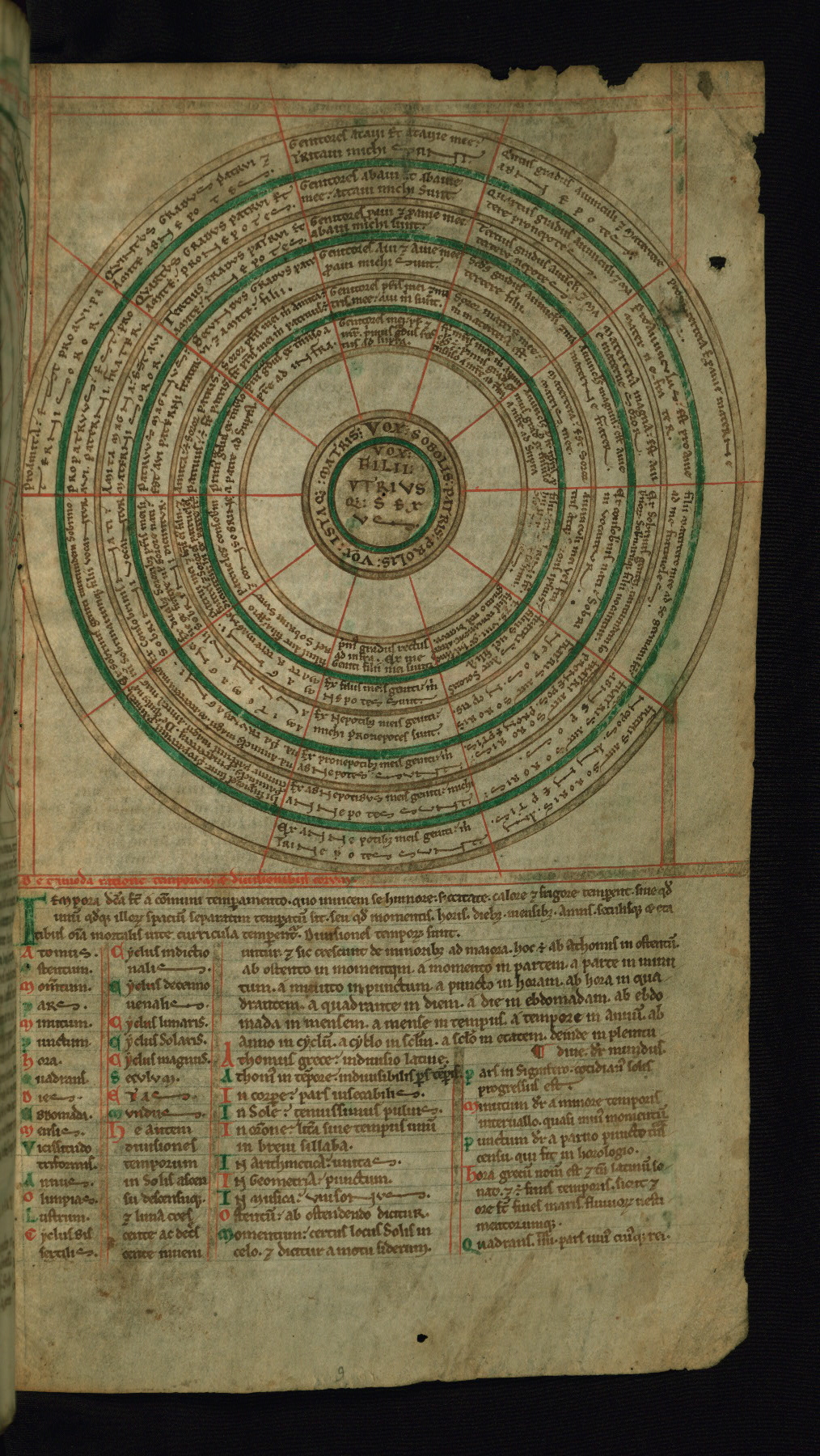
- Title: Consanguinity chart
- Form: Half-page illustration
- Text: Isidore: De trimoda ratione temporum et divisionibus eorum
- Label: This wheel-shaped diagram sets out the degrees of kinship that determine whether two individuals related by blood may marry. Diagrams of consanguinity also were used to determine inheritance when the deceased left no will. The six concentric rings of the diagram represent six generations of a family. Each ring is divided into ten sectors, in which are written the bloodlines of family descent and connections.
- Comment:
At the center of the diagram: “Vox filii utriusque sexus.” In the band around the center, beginning at top: “Vox sobolis patris prolis vox ista que matris.” In the surrounding bands, the inscriptions describe and name the various relations that an individual might have, e.g.: “Genitores patris mei et et matris mee avi mihi sunt,” or “The parents of my father and mother are my grandparents”; “Proamita est proavi paterni soror,” or “[My] paternal great-aunt is the sister of [my] paternal great-grandfather”; “Filii matertere mee ad se germani et ad me fratrueles,” or “The children of my aunt are brothers to themselves and cousins to me.” They are arranged into ten categories, beginning at the top and proceeding clockwise: father and mother and their parents; from maternal uncles and aunts and their children; maternal uncles and aunts and their parents; maternal cousins; nephews and nieces; sons and daughters and their children; aunts and uncles; paternal cousins; paternal uncles and aunts and their parents; paternal uncles and aunts and their children.
In medieval scientific manuscripts, material on consanguinity was presented in three formats: as a tree diagram, a step diagram, and as a wheel-shaped diagram, as in W.73, fol. 9r. The tree diagram was the most popular schema. A tenth-century manuscript made at Saint-Martial, France, contains all three types of diagram; see Paris, Bibliothèque nationale de France, Ms. latin 5239, fols. 163r-166r. In some scientific and legal manuscripts, the table of consanguinity is superimposed on a human figure. In a manuscript of Isidore’s Etymologiae made ca. 1160-65 at the German monastery of Prüfening, the consanguinity chart becomes the body of Adam; see Munich, Bayerische Staatsbibliothek, Clm 13031, fol. 102v. In a manuscript of the Decretals of Gregory IX made in Paris or Sens ca. 1170-80, the consanguinity table is superimposed on the image of God; see Los Angeles, J. Paul Getty Museum, Ms. Ludwig XIV 2, fol. 227v.
The binding is not original.
Bound in the late nineteenth or early twentieth century by Léon Gruel in Paris; brown calf over mill-board, scorched line border, gold fillet on board edges, three gold fillets on turn-ins; title scorched in spine "Cosmographia"
Created in England, late twelfth century, for monastic use
Gruel and Englemann collection, Paris, no. 131, bookplate inside upper board
Acquired by Henry Walters from Léon Gruel, June 9, 1903
Walters Art Museum, 1931, by Henry Walters' bequest
De Ricci, Seymour. Census of Medieval and Renaissance Manuscripts in the United States and Canada. Vol. 1. New York: H. W. Wilson Company, 1935, p. 826, no. 412.
Edson, Evelyn. Mapping Time and Space: How Medieval Mapmakers Viewed Their World. London: British Library, 1997, p. 70.
Bober, Harry. "An Illustrated Medieval School-Book of Bede's 'De Natura Rerum'." Journal of the Walters Art Gallery, 19-20 (1957): pp. 64-97.
Destombes, Marcel. Mappemondes, A.D. 1200-1500: Catalogue préparé par la Commission des cartes anciennes de l'Union géographique internationale. Amsterdam: N. Israel, 1964, pp. 166-167, cat. no. 49.
Howard, Donald. The Idea of the Canterbury Tales. Berkeley: University of California Press, 1976, p. 204, fig. 11 (fol. 1v); p. 206, n. 79; pp. 204, 206.
Caviness, Madeline. Images of Divine Order and the Third Mode of Seeing. Gesta 22, no. 2. (1983): pp. 99-120 (does not cite Ms. by number, but refers to Bober article, pp. 104, 117, n. 29).
Eastwood, Bruce S. and Gerd Grasshoff. Planetary Diagrams for Roman Astronomy in Medieval Europe, c. 800-1500. Transactions of the American Philosophical Society 94, pt. 3. Philadelphia: American Philosophical , 2004, p. 11 n. 26.
Eastwood, Bruce. Latin Planetary Studies in the IXth and Xth Centuries. Florence: Leo S. Olschki, 1996, fig. 11 (fol. 5v); p. 221.
Kline, Naomi Reed. Maps of Medieval Thought: The Hereford Paradigm. Woodbridge, UK: Boydell, 2001, pp. 21-23 (fols. 1v, 2r, 8r).
Feltman, Jennifer M. "Inscribing Order: The Didactic Function of The Walters Art Museum Ms. 73." Athanor 25 (2007): pp. 7-16.
The Calendar and the Cloister: A Full Digital Facsimile of the St. John’s Computus, Oxford, St. John's College Ms. 17, with commentary, background essays, and other apparatus and material; http://digital.library.mcgill.ca/ms-17/index.htm.
Cleaver, Laura. "On the Nature of Things: The Content and Purpose of Walters W.73 and Decorated Treatises on Natural Philosophy in the Twelfth Century." Journal of the Walters Art Museum 68-69 (2010-2011): pp. 21-30, figs. 1 (fol. 1v), 4 (fols. 6v-7r).
Gerry, Kathryn. "A Medieval Scientific Book for Monastic Use." In Melanie Holcomb, Pen and Parchment: Drawing in the Middle Ages. New York: Metropolitan Museum of Art, and New Haven: Yale University Press, 2009, pp. 108-110, no. 29.
Bede. 'On the Nature of Things' and 'On Times.' Trans. with introduction, notes, and commentary by Calvin B. Kendall and Faith Wallis, Translated Texts for Historians, vol. 56. Liverpool: Liverpool University Press, 2010, pp. 42, 45.
Principal cataloger: Smith, Kathryn
Cataloger: Walters Art Museum curatorial staff and researchers since 1934
Editors: Herbert, Lynley; Noel, William
Copy editor: Dibble, Charles
Conservators: Owen, Linda; Quandt, Abigail
Contributors: Bockrath, Diane; Emery, Doug; Houston, Daniel; Kauffman, Nicholas; Noel, William; Tabritha, Ariel; Toth, Michael B.
The Walters Art Museum
Licensed for use under Creative Commons Attribution-NonCommercial-ShareAlike 3.0 Unported Access Rights, http://creativecommons.org/licenses/by-nc-sa/3.0/legalcode. It is requested that copies of any published articles based on the information in this data set be sent to the curator of manuscripts, The Walters Art Museum, 600 North Charles Street, Baltimore MD 21201.